Wednesday, May 27, 2009

A Memorial Weekend

I really wish I could have every Monday off.
The amazing May continues. 3 beautiful days of weather. So what do I do on the first day?
Go play in the shade of the Sicky, sicky north face of Flattop. Yeah yeah, snicker all you want. I've wanted to take a closer look at Alaska's deadliest mountain in search of that north facing not quite so chossy rock I'd heard about. We found some. Climbed a few short cracks that made the 30 minute hike worth it. Scrambling up, looking for fun moves on the blocks was also a good time.

Sunday was spent converting a slag pile in the back of the house into something more useful. A small garden plot.

Here's the before and after.


I call this a slag pile because it was basically a pile of construction detritus. It had concrete, cinder blocks, rebar, wood, and other trash in it. I was able to use some of that waste for the frame of the plot. Score one for reusing construction waste!!!

Planting will commence this week. Yes I bought starts, lots of standard stuff, we'll see what actually grows. This isn't a really sunny spot.

Sunday I feel a bit sheepish admitting was spent skiing at Turnagain. My newest climbing partner had cut up his hands some on our wicked ascent ;-) of Flattop the other day and didn't think another day of climbing was a good idea. So I semi-begrudgingly accepted to go skiing. The skiing was better than expected, we were able to skin basically from the car. We investigated Todd's on Tincan but something about the fall line being melted out to rock didn't look that good. So we opted for a few laps on the standard Tincan shelves. This was after lounging in the sun for an hour or so. The type of thing you only dream about in February on the same peak.
Better than expected...


Pastoral looking inviting...


Heard lots and lots of SSSSSsssssssssssssssssssssssssssssss..... (the sound of spring snow creeping downhill ever sooooo slowly) but in general, it wasn't a bad way to spend a Memorial Day.

Friday, May 15, 2009

Ruth Gorge, Alaska Range, May 2009

After many discussions, a few volcanic eruptions, a few hours of looking at maps, and a couple partner changes, a rather obvious decision was made for our spring mountaineering trip. The stunning and rather easily accessible Ruth Gorge of the Alaska Range it would be. Immediately I began recalling the routes from Joe Puryear's new guide book, trying to figure out what were possible objectives.

I was to find out that staring at the map of the area does not really do the Gorge justice. Only once you are flying what feels like feet away from the massive 5,000' buttress of Mt. Dickey do you begin to contemplate how massive these hunks of rock are.

Myself, Billy Finley, his wife Yvonne Lamoureux and Austin Thayer headed up to Talkeetna on May 2nd. Upon arriving in Talkeetna, we assumed flying in that day wasn't going to be an issue.


Token shot of Denali from near Talkeetna. It was one of those days where even folks from in-state were stopping to take pictures.


I
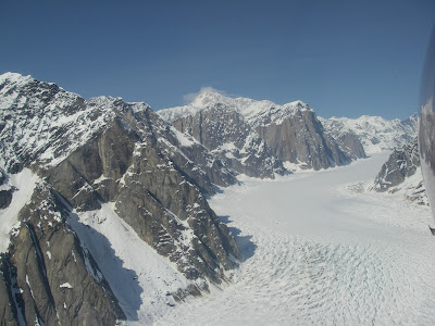
've got too many amazing photos from the flight in, but this one represents my first impression of the gorge... you get the idea. This is the Ruth from the southern end.


We had excellent flying conditions. The fine weather would stay with us for pretty much the whole trip.


Standard airplane, gear, teammates pic. With not so standard alpine background.


The next day dawned clear and not so cold. Our ambitions were actually kind of low, bolstered particularly by everyone's camps being occupied by eager looking climbers that first morning we were there.

We had heard that a large storm deposited 3-4 feet of snow the previous week. That afternoon we were to see the effects of this storm were still lingering.


The group decided a mellow tour up to 747 Pass, the access route to Mt. Dickey would make for a good first outing. With temps rising fast, up we went.

747 Pass with Dickey on the right. Note the apparently nice, clear ice-free path up to the pass.


We decided to take a few steps up the back side of Dickey just because the existing steps looked so inviting. The mid afternoon sun eventually turned our semi-slog into a full on hip deep nasty wallow. It didn't take long to decide to turn around and call it a day.


Not before getting some shots of surrounding peaks, including Huntington and Denali.


The ski back down 747 provided more excitement than expected. Dickey was puking globs of snow down into the pass pretty regularly (from high on walls on R side of previous pic) and in one instance uncomfortably close (my first powderblast). To top it off, the snow in the pass had re-frozen into a difficult mank/breakable crust which gave some in the team difficulties. The excitement didn't stop there as the icefall debris from neighboring Mt. Bradley reminded us there really were no safe spots in the valley. We high tailed out as fast as we could having learned some excellent lessons our first day in the gorge.
For me, the non stop objective hazards kind of took me by surprise. They were everywhere! Icefall, avys, crevases, sun, rockfall and so on!


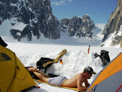
Day three was supposed to be an exploratory day, cruising for routes. I don't think I even left camp that day as it felt so beach-like. Austin took advantage of the abnormally warm temps.


Day four came with an early start. We were going for Mt. Barrille, the Japanese Colouir route.
Still the temperatures remained warm. We awoke to barely even an eggshell crust on the snow in camp and a bit of snow/sleet as we left camp. Everyone agreed that since we were up and had drank coffee we should at least go look at the route. I know I wasn't really expecting much that morning as we skied out of camp.
Trippy darkness setting pic of Austin tying in under the hood, staying out of the rain...


Surprisingly, the col offered relatively decent snow conditions. The higher we got, the better it got. We worked in and around the deepest avy runnels finding mostly solid snow. I soon began the game I play when climbing looong snow routes. Pick out an object, say a particular rock or streak of color and climb until it is reached. Then repeat, then repeat....

Here is Yvonne, Austin and Billy low in the Japanese Colouir.


We managed to solo the entire col without any issues. The top sported a steep section of near bottomless snow with a cornice that fortunately overhung the other way. Also fortunately the previous groups steps had been preserved enough that we were able to waddle our way up to the top using them.


Billy at the top in deteriorating weather.


After the col you need to traverse a slope to gain a steep gully that takes you to the summit ridge.
The summit ridge was a near whiteout for most of the time we were up there. Austin found the way and after a series of ups and downs and a few cornice crossings we found ourselves with nowhere else to climb. The summit!
Sorry, no summit pics, we didn't waste much time heading back down. There wasn't a lot to be seen anyways due to the storm.
Our descent route followed the ascent.


Here is one picture of Yvonne starting a rappel, of which we did 6 total and downclimbed the rest. Round trip was around 14 hours, camp to camp.


The next day was a deserved rest day complete with pancakes, coffee, mid morning coffee, a huge lunch and probably early afternoon coffee as well.


The next two days were spent on an attempt on the western face of Mt. Dan Beard.
The standard route is an awkward linkage of the weak spots on the southern face of the peak. Given Turnagain Softcore
(that was the name of our team as registered with the NPS) is not your standard climbing team, we decided to try a route on the western side of the mountain. The route on the Bradford Washburn Denali map looked reasonable aside from a few heavily cracked up glaciers that would need to be crossed. We took out of camp a little late and within an hour or so we were smack in the middle of the Ruth Amphitheater and it was HOT!


(L)Billy and Yvonne in front of the Japanese Colouir after doing a"crevasse run" (thanks!)
(R)The Root Canal Glacier and the amazing Moose's Tooth


(T) First look at Dan Beard. We would be attempting a route on the left side of the peak.
(B)First we had to negotiate the crevasses along the left side of the rock band in the foreground.
Peak 11,300 and Denali provide a nice background. We ended up traveling about 8 miles to set up another camp for the attempt on Dan Beard.


Other sights...

(T) Backside of Barrill with Dickey in the background. (B) Why not.... Moose's Tooth once again with our ski tracks.


(T think Top Gun) Dah du dah dah, dah du dah dah, "riiiiide into the danger zone!!!" Billy leads us safely through some seriously crevassed terrain complete with a few saggy snow bridges!!!
(B)Looking up valley towards our proposed route. Dan Beard is the peak on the right. We were hoping to make one of those snow routes go. We see lots more crevases and.... icefall :-( Lots of icefall...


The next morning, minus Austin who had possibly picked up a bug from the next camp over, we headed up valley, weaving in and out between the massive yawners (that's climber speak for crevasses).

Alas it appeared the route would not go without exposing ourselves to a potentially hazardous section of icefall. We decided to wait for the sun and during that time we saw a massive icefall/avalanche come down from high on Denali's east side.


We headed back down to camp, getting some sweet roped up turns in on the lower, un-crevassed section.

We packed up camp and took out for basecamp. The trip back was much easier with slightly lower temps and a gentle downhill slope back into the Ruth.

That evening Austin caught a flight back to Talkeetna. He needed to be at work on Monday. And then Turnagain SC was down to three members.


Billy and I made hasty plans that night to try a route that had been calling my name since I first saw it, Freezy Nuts, on the Warewolf.
Unfortunately, the illness that dogged Austin was moving through Turnagain Softcore. The next day ended up being a rest and recovery day for all. Freezy Nuts would have to wait.

Day 9 was set for the impressive Mt. Dickey. The route we took went up 747 pass to the south of the peak and accessed the west ridge. This is probably the easiest route in the Gorge with very little if any technical climbing. Route finding is the key as this mountain has the largest crevasses I have ever seen.

The route consisted of entirely snow climbing with varying degrees of steepness. We protected with pickets where needed. We had for the most part good snow conditions. Lucky for us the day was partly cloudy and the upper parts of the mountain stayed shrouded in clouds most of the day. The crux was a steep climb up a face below a cornice that also had to be overcome. I drew this and despite the crumbly snow, I really enjoyed pulling over the cornice lip. Mainly because the snow in the actual cornice was super solid. One ax plant and haul yourself up!!

Pics from the ascent...


Dickey had an amazing summit ridge with impressive views, exposure and more than one "summit bump" (more like 3 or 4!)


The summit offered amazing views in all directions. But I pretty much only took pictures of the Moose's Tooth!
The downclimb was uneventful. There is a large face traverse that is difficult to avoid. Again we placed pickets and once our system was down we were covering ground relatively fast.

If you recall me mentioning to remember a nice, clear path up to 747 Pass? One morning we woke up to a rather shocking view. A very large icefall had occurred that covered our tracks from our outing on our first day. This was rather disconcerting as we all knew we would have to cross this twice in order to climb Dickey. We jokingly talked about the odds of being killed by icefall being less than being struck by lightning and quickly got across the icy carnage.
Here's a pic and video from where we crossed.


Dickey was followed by another warm rest day.


The following morning and last climbing day of the trip was reserved for Freezy Nuts on the Warewolf Tower.
This morning Yvonne was feeling a bit under the weather, so Billy and I went as a two man team. We got up at 2 AM, slammed some breakfast and coffee and a very quick cruise across a solidly frozen glacier surface got us to the base of the climb by 3:30.

Freezy Nuts
We solo'd the first ~1000' or so on varying snow quality. The base was awful, punchy, unconsolidated crap. My heart sank as I started kicking the first steps and each step sunk in over my boot top, sometimes up to my knee, other times even higher.
But preserverance paid off. I searched for the stiffest avy debris and eventually the snow got better and continued to improve the higher we got.

We roped up roughly where the route narrows down and began simulclimbing for a few pitches placing mostly pickets, the occasional pin or cam with Billy in the lead.

The snow eventually turned into snice and then easy to moderate ice with brief sections of spindrift buildup wallows. Conditions the up in the slot were in general, pretty good with some really cool terrain. Once onto the ice we began swapping leads which kept up until the end.


I found myself looking down and out the slot on the way up. Catching a beautiful sunrise on the peaks across the gorge and on Mt. Huntington.


More pics from the up on Freezy Nuts...

(T) Billy leading out low in the slot. (B) Billy approaching a cool rock/ice step about midway through the slot.

The walls on either side were near vertical and stretched for several hundred feet. In some places they were smeared with ice, others had curtains of icicles hanging from them.


(T) Ice smeared walls. They were cool in the morning when they were good and frozen! In the afternoon they were cascading water down the route.

(B) Billy coming up to an ice belay


The slot opens up after 5 or 6 pitches. The steepness kicks up and there is no more ice. Just snow, some of it not so good.

(T) Billy leads out on the second to last pitch. (B) The last pitch had a required snow tunnel section. Fortunately for me the tunnel was already dug and required only minimal excavation on my part.


We rapped the entire route, building some anchors, backing up others and using a v-thread or two. This was definitely not a speed record, we returned to camp around 10 that night, making for around a 19 hour day!


The next day it was time to leave our home on the glacier.

TAT showed up, we piled our gear in, our pilot did this amazing cross wind, last second correction landing maneuver and within an hour we were back in Talkeetna ordering two Mountain High Pizza Pies
:-)


Billy posted a great trip report with awesome pictures and funny captions over here:
http://www.peakaweek.com/index.cfm?section=mountains&page=Alaska&cat=Alaska%20Range&viewpost=2&ContentId=576